To ensure you’re receiving the most up-to-date and accurate information, please choose the correct agency from the homepage. The DHEC website is no longer being updated and will be permanently unavailable Dec. 31, 2024.
A hurricane is the most severe category of "tropical cyclone" - a general term for all circulating weather systems over tropical waters. When the winds of a tropical cyclone reach a constant speed of 74 miles per hour or more and the storm has a well-defined counterclockwise circulation, it is called a hurricane.
Hurricane winds blow in a large spiral around a relatively calm center known as the "eye." The "eye" is generally 20 to 40 miles wide, and the entire storm may have a diameter of 400 miles across. A hurricane can bring torrential rains, high winds, and a storm surge as it nears land. A single hurricane can last more than two weeks over open waters and can run a path across the entire length of the eastern seaboard. More detailed information about tropical storms and hurricanes can be found at the National Hurricane Center's website.
Hurricanes usually occur between June 1 and November 30. Each year, on average, ten tropical storms (of which six become hurricanes) develop over the Atlantic Ocean, Caribbean Sea, or Gulf of Mexico. Many of these remain over the ocean. However, about five hurricanes strike the United States coastline every three years. Of these five, two will be major hurricanes (category 3 or greater on the Saffir-Simpson Scale). For information on how hurricanes are named, visit Worldwide Tropical Cyclone Names.
Saffir-Simpson Hurricane Scale
- Category 1 - Winds : 74-95 mph (64-82 kt)
(Storm surge 4 - 5 ft. above normal)
No real damage to building structures. Damage primarily to unanchored mobile homes, shrubbery, and trees. Also, some coastal flooding and minor pier damage. Examples: Irene 1999 and Allison 1995. - Category 2 - Winds : 96-110 mph (83-95 kt)
(Storm surge 6 - 8 ft. above normal)
Some roofing material, door, and window damage. Considerable damage to vegetation, mobile homes, etc. Flooding damages piers and small craft in unprotected moorings may break their moorings. Examples: Bonnie 1998, Georges (FL & LA) 1998 and Gloria 1985. - Category 3 - Winds : 111-129 mph (96-112 kt)
(Storm surge 9 - 12 ft. above normal)
Some structural damage to small residences and utility buildings, with a minor amount of curtainwall failures. Mobile homes are destroyed. Flooding near the coast destroys smaller structures with larger structures damaged by floating debris. Terrain may be flooded well inland. Examples: Keith 2000, Fran 1996, Opal 1995, Alicia 1983 and Betsy 1965. - Category 4 - Winds : 130-156 mph (113-136 kt)
(Storm surge 13 -18 ft. above normal)
More extensive curtainwall failures with some complete roof structure failure on small residences. Major erosion of beach areas. Terrain may be flooded well inland. Examples: Andrew (FLORIDA) 1992, Hugo 1989 and Donna 1960. - Category 5 - Winds : 157+ mph (137+ kt)
(Storm surge more than 18 ft. above normal)
Complete roof failure on many residences and industrial buildings. Some complete building failures with small utility buildings blown over or away. Flooding causes major damage to lower floors of all structures near the shoreline. Massive evacuation of residential areas may be required. Disaster prevention should include: Developing a Family Plan and Creating an Emergency Supply Kit.
Hurricane Watches and Warnings
- Tropical Storm Watch: Tropical Storm conditions (winds 39-73 mph) are possible in the specified area of the Watch, usually within 36 hours.
- Tropical Storm Warning: Tropical Storm conditions are expected in the specified area of the Warning, usually within 24 hours.
- Hurricane Watch: Hurricane conditions are possible in the specified area of the Watch, usually within 36 hours. During a Hurricane Watch, prepare to take immediate action to protect your family and property in case a Hurricane Warning is issued.
- Hurricane Warning: Hurricane conditions are expected in the specified area of the Warning, usually within 24 hours. Complete all storm preparations and evacuate if directed by local officials.
Tidal Surge
Tidal surge or storm surge is an abnormal rise of sea level along a shore, primarily resulting from the winds of a storm. The graphic below demonstrates the increase in tidal surge with the corresponding storm category. For more information regarding storm surge and hurricanes, please visit NOAA's website.

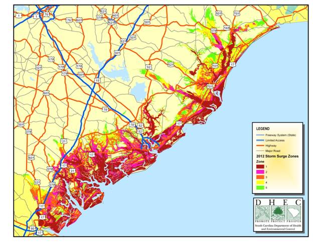
Areas of Vulnerability
The areas of vulnerability depicted on the map below indicate areas where people may be ordered to evacuate due to tidal surge hazards. If you do not live in the areas indicated below, you may still be vulnerable to flooding and high winds.
